Fichier:Ireland geographical map.png
Pas de plus haute résolution disponible.
Ireland_geographical_map.png (150 × 190 pixels, taille du fichier : 50 kio, type MIME : image/png)
| Description |
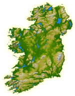
English: Topography of Ireland |
| Date | IotD Date 2005-03-18 |
| Source |
NASA: IotD ID 16853 – http://visibleearth.nasa.gov/view_rec.php?id=17124 |
| Auteur | NASA, see Image:Topography Ireland.jpg for more information |
| Autorisation (Réutilisation de ce fichier) |
public domain |
| Autres versions | original, bigger version at Image:Topography Ireland.jpg |
| Ce fichier provient de la NASA. Sauf exception, les documents créés par la NASA ne sont pas soumis à copyright. Pour plus d'informations, voir la politique de copyright de la NASA. | ||
 |
Attention :
|
Historique du fichier
Cliquer sur une date et heure pour voir le fichier tel qu'il était à ce moment-là.
| Date/Temps | Vignette | Dimensions | Faichonneu | Commentaire | |
|---|---|---|---|---|---|
| actuel | 11 de juilet 2005 à 11:39 | | 150 × 190 (50 kio) | Kanchelskis | Map of Ireland lightened. Author:me {{GFDL}} Category: Ireland |
Lians
Ches pages ont un lian à chu portrait:
Usage global du fichier
Les autres wikis suivants utilisent ce fichier :
- Utilisation sur de.wikipedia.org
- Utilisation sur en.wikipedia.org
- User:Jtdirl
- User:Kwekubo
- Dingle Peninsula
- User:Zoney
- Iveragh Peninsula
- User:Ropers
- User:Gerry Lynch
- User:AndrewH
- User:Ebelular
- Inishowen
- User:Fergananim
- Mizen Head
- Sheep's Head
- Old Head of Kinsale
- User:Rye 212
- Ards Peninsula
- User:Blorg
- User:Wexfordman
- User:Meabhar~enwiki
- Howth Head
- User:Sean3000
- User:Notjim
- User:Jasonm
- User:Kgaughan
- Beara Peninsula
- User:John Carroll
- User:Bjimba
- User talk:Lochaber
- Fanad
- User:Hetch
- Islandmagee
- User:Wikipedian231
- User:Jdorney
- User:Merlante
- User:Lugnad
- Slieve League
- User:Ben-w
- Hook Peninsula
- User:Polar ice
- User:Dowlingm
- User:Frure
- User:Ventolin
- User:Dkie
- User:Colm Rice
- Mullaghmore, County Sligo
- User:Damac
- User:Ian Cheese
- User:Tpower
- User:Raemie
Voir davantage sur l’utilisation globale de ce fichier.